
GIS Projects
GIS and geospatial data communication professional with a multidisciplinary background in spatial analysis, geospatial data management, remote sensing, cartography, data visualization, environmental planning, graphic design, and land stewardship. Skilled in using GIS to integrate and analyze spatial data, identify patterns and relationships, evaluate environmental and infrastructure conditions, and translate complex information into clear maps, visualizations, and decision-support products. Projects explore applications across environmental and municipal planning, conservation, water resources, infrastructure, renewable energy, land use, and natural resource management.

Development Suitability & Communications Infrastructure Assessment
Raster Suitability Modeling & Viewshed Analysis
Evaluated development suitability and communications tower visibility within Vermont's Mad River Valley by integrating terrain, land cover, environmental constraints, and accessibility datasets. Applied raster analysis, spatial modeling, cost distance, and viewshed analysis in ArcGIS Pro to identify suitable development areas, evaluate potential communications coverage, and produce decision-support maps for land use and infrastructure planning.
Project Context: Originally developed through the University of Vermont's Advanced GIS course (GIS & Data Communication Certificate) and later refined for my professional portfolio.
Software: ArcGIS Pro
Raster & Spatial Analysis: Raster Analysis, Spatial Analysis, Map Algebra, Terrain Analysis, Land Cover Analysis, Euclidean Distance Analysis, Cost Distance Analysis, Viewshed Analysis
Planning & Decision Support: Site Suitability Modeling, Land Use Planning, Infrastructure Planning,
Spatial Decision Support
Cartography & Visualization: Cartography, Data Visualization

Residential Proximity to Impaired Waterways
400-Meter Residential Property Analysis
Identified residential properties located within 400 meters of Section 303(d) impaired waterways along the Winooski River and Stevens Branch in central Vermont. Applied spatial selection, proximity analysis, and cartographic techniques in ArcGIS Pro to evaluate the spatial relationship between residential development and impaired surface waters, and produce decision-support maps for environmental planning and water
resource management.
Project Context: Originally developed through the University of Vermont's Advanced GIS course (GIS & Data Communication Certificate) and later refined for my professional portfolio.
Software: ArcGIS Pro
Spatial Analysis: Spatial Analysis, Proximity Analysis, Buffer Analysis, Spatial Selection
Environmental Applications: Water Resources, Surface Water Analysis, Environmental GIS
Planning & Decision Support: Environmental Planning, Spatial Decision Support
Data Management: GIS Data Management, Metadata Documentation
Cartography & Visualization: Cartography, Map Layout Design, Data Visualization

Vermont Housing Vacancy Analysis
County-Level ACS Data & Thematic Mapping
Analyzed county-level housing vacancy patterns across Vermont using 2019 U.S. Census American Community Survey (ACS) data. Integrated tabular and spatial datasets through attribute joins, calculated county housing vacancy rates, and produced a choropleth map illustrating regional patterns relevant to housing planning, community development, and regional policy analysis.
Project Context: Originally developed through the University of Vermont's Advanced GIS course (GIS & Data Communication Certificate) and later refined for my professional portfolio.
Software: ArcGIS Pro
Data Analysis & Integration: Census Data Analysis, Tabular Joins, Attribute Joins, Summary Statistics,
GIS Data Integration
Planning & Decision Support: Housing Planning, Community Planning, Community Development,
Regional Analysis
Cartography & Visualization: Thematic Mapping, Choropleth Mapping, Cartography, Data Visualization

Forest Canopy Assessment of Vermont Conservation Priority Areas
Conservation Priority Overlay & Zonal Analysis
Evaluated forest canopy conditions within Vermont conservation priority areas by integrating National Land Cover Database (NLCD) tree canopy data with Representative Landscapes and Biological Hotspots datasets. Applied spatial overlay analysis and zonal statistics in ArcGIS Pro to quantify canopy cover within overlapping conservation areas and produce decision-support maps for biodiversity conservation, forest management, and natural resource planning.
Project Context: Originally developed through the University of Vermont's Advanced GIS course (GIS & Data Communication Certificate) and later refined for my professional portfolio.
Software: ArcGIS Pro
Spatial Analysis & Modeling: Spatial Analysis, Raster Analysis, Vector Analysis, Overlay Analysis, Zonal Statistics
Environmental Applications: Conservation Planning, Forest Canopy Analysis, Biodiversity Assessment, Environmental GIS
Planning & Decision Support: Natural Resource Planning, Conservation Decision Support
Cartography & Visualization: Cartography, Data Visualization

Emergency Response Network Analysis
Fire Station Response Accessibility Analysis
Evaluated emergency response accessibility across Chittenden County, Vermont, using ArcGIS Network Analyst. Applied closest facility, service area, and route optimization analyses to model fire station response times, assess accessibility to government facilities, and produce decision-support maps for emergency response planning and public safety infrastructure.
Project Context: Originally developed through the University of Vermont's Advanced GIS course (GIS & Data Communication Certificate) and later refined for my professional portfolio.
Software: ArcGIS Pro, ArcGIS Network Analyst
Network & Spatial Analysis: Network Analysis, Closest Facility Analysis, Route Optimization, Service Area Analysis, Spatial Analysis
Planning & Decision Support: Emergency Response Planning, Public Safety Planning, Transportation Analysis, Infrastructure Planning
Data Management: GIS Data Management
Cartography & Visualization: Cartography, Data Visualization

Watershed Development & Forest Conservation Assessment
Hydrologic & Landscape Analysis of the Mad River Valley
Conducted a watershed-scale analysis of Vermont's Mad River Valley by integrating hydrologic, land cover, impervious surface, property assessment, and forest conservation datasets. Applied ArcGIS Pro hydrology tools, raster analysis, zonal statistics, and tabulate intersection to evaluate watershed characteristics, forest canopy change, development pressure, and land enrolled in Vermont's Use Value Appraisal (Current Use) Program. Produced decision-support maps for watershed management, conservation planning, and land
use decision-making.
Project Context: Originally developed through the University of Vermont's Advanced GIS course (GIS & Data Communication Certificate) and later refined for my professional portfolio.
Software: ArcGIS Pro
Hydrologic & Spatial Analysis: Hydrologic Analysis, Watershed Delineation, Spatial Analysis, Raster Analysis, Flow Direction, Flow Accumulation
Spatial Modeling & Statistics: Zonal Statistics, Tabulate Intersection, Buffer Analysis
Environmental Applications: Watershed Management, Land Cover Analysis, Forest Canopy Analysis, Conservation Planning, Environmental GIS
Planning & Decision Support: Land Use Analysis, Development Pressure Analysis, Natural Resource Planning
Cartography & Visualization: Cartography, Data Visualization

Coordinate System Standardization Workflow
Coordinate System Management & Spatial Data Standardization
Standardized spatial datasets for regional GIS analysis by identifying an undefined coordinate system, defining the appropriate spatial reference, and reprojecting datasets into a common equal-area coordinate system. Applied ArcGIS Pro data management and projection workflows to ensure accurate spatial alignment, improve data interoperability, and establish a standardized foundation for reliable regional spatial analysis.
Software: ArcGIS Pro
Coordinate Systems & Projections: Coordinate System Management, Spatial Reference Management, Define Projection, Project Tool
Data Management & Quality: Spatial Data Standardization, GIS Data Management, Data Interoperability, Geospatial Data Quality, QA/QC
Workflow Development: GIS Workflow Development

Parcel-Level Building Footprint Inventory
Building Footprint Digitization & Geospatial Data Development
Developed a parcel-level building inventory by digitizing building footprints from aerial imagery in Montpelier, Vermont. Applied feature editing, attribute development, overlay analysis, and metadata documentation in ArcGIS Pro to create and validate geospatial datasets, quantify building coverage, and support GIS data management, quality assurance, and geodatabase development.
Project Context: Originally developed through the University of Vermont's Advanced GIS course (GIS & Data Communication Certificate) and later refined for my professional portfolio.
Software: ArcGIS Pro
Data Creation & Editing: Feature Editing, GIS Digitization, Spatial Data Creation, Attribute Development
Data Management & Quality: Geodatabase Management, GIS Data Management, Metadata Documentation, Data Validation, QA/QC
Spatial Analysis: Spatial Analysis, Overlay Analysis
Cartography & Visualization: Cartography

Landsat 8 Multispectral Imagery Interpretation
Spectral Band Composites & Land Cover Interpretation
Processed and interpreted Landsat 8 multispectral satellite imagery to evaluate vegetation and land cover patterns across Chittenden County, Vermont. Applied spectral band combinations and image interpretation techniques to produce natural color and color infrared composites, enhancing the visualization and interpretation of vegetation, developed areas, water bodies, and other land cover types for environmental and land use analysis.
Project Context: Originally developed through the University of Vermont's Advanced GIS course (GIS & Data Communication Certificate) and later refined for my professional portfolio.
Software: ArcGIS Pro
Remote Sensing & Earth Observation: Remote Sensing, Landsat 8, Multispectral Imagery, Satellite Image Interpretation, Color Infrared Analysis, Natural Color Composites
Environmental Applications: Vegetation Analysis, Land Cover Analysis, Environmental GIS
Cartography & Visualization: Cartography, Data Visualization

Remote Sensing & Vegetation Density Analysis
NDVI, Multispectral Imagery & Spatial Analysis
Processed Landsat 8 multispectral satellite imagery to evaluate vegetation density and land cover patterns across Chittenden County, Vermont. Applied spectral band combinations to generate natural color and color infrared composite imagery, calculated the Normalized Difference Vegetation Index (NDVI), and summarized vegetation density by census block group using zonal statistics. Integrated satellite-derived vegetation metrics with population density data to examine spatial relationships between urban development and green space distribution, producing maps and visualizations relevant to environmental planning and land use analysis.
Project Context: Originally developed through the University of Vermont's Advanced GIS course (GIS & Data Communication Certificate) and later refined for my professional portfolio.
Software: ArcGIS Pro
Remote Sensing & Earth Observation: Remote Sensing, Landsat 8, Multispectral Imagery, Satellite Image Interpretation, NDVI Analysis, Spectral Indices
Raster & Spatial Analysis: Raster Analysis, Spatial Analysis, Zonal Statistics, Statistical Analysis
Data Analysis & Integration: Census Data Integration, Population Density Analysis, Environmental Data Integration
Planning & Decision Support: Environmental Planning, Land Use Analysis, Green Space Analysis
Cartography & Visualization: Cartography, Data Visualization

Headwaters Black Creek Watershed Assessment
Hydrologic, Land Cover, and Wetland Characterization
Integrated hydrologic boundaries, stream networks, land cover, and wetland datasets to characterize watershed conditions within Vermont's Headwaters Black Creek watershed. Applied spatial and hydrologic analysis
and cartographic techniques in ArcGIS Pro to examine landscape patterns and produce thematic maps and summary statistics supporting watershed planning, conservation, and natural resource management.
Project Context: Originally developed through the University of Vermont's Advanced GIS course (GIS & Data Communication Certificate) and later refined for my professional portfolio.
Software: ArcGIS Pro
Spatial & Hydrologic Analysis: Spatial Analysis, Hydrologic Analysis, Watershed Analysis, Land Cover Analysis
Environmental Applications: Wetland Mapping, Environmental GIS
Cartography & Visualization: Cartography, Data Visualization
Data Management: GIS Data Management

Solar Energy Potential Assessment for Vermont's Mad River Valley
Raster-Based Solar Resource & Land Cover Analysis
Integrated modeled solar resource density with forest canopy data to evaluate patterns of solar energy potential across Vermont's Mad River Valley. Applied raster-based spatial modeling and analysis techniques in ArcGIS Pro to identify areas with varying solar resource potential and produce a decision-support map relevant to renewable energy planning and land management.
Project Context: Originally developed through the University of Vermont's Advanced GIS course (GIS & Data Communication Certificate) and later refined for my professional portfolio.
Software: ArcGIS Pro
Raster & Spatial Analysis: Raster Analysis, Spatial Analysis, Spatial Modeling, Point Density Analysis, Raster Calculator, Conditional (Con) Analysis
Planning Applications: Renewable Energy Planning, Land Suitability Analysis, Environmental GIS
Cartography & Visualization: Cartography, Data Visualization

Residential Site Suitability Assessment for the Winooski River Basin
Multi-Criteria Spatial Analysis for Development Planning
Integrated environmental and development datasets, including canopy cover, residential density, transportation infrastructure, development pressure, and proximity to impaired waterways, to evaluate residential development suitability within Vermont's Winooski River Basin. Applied multi-criteria decision analysis, weighted overlay modeling, raster analysis, and proximity analysis in ArcGIS Pro to identify candidate areas and produce decision-support maps for land use and environmental planning.
Project Context: Originally developed through the University of Vermont's Advanced GIS course (GIS & Data Communication Certificate) and later refined for my professional portfolio.
Software: ArcGIS Pro
Spatial Modeling & Analysis: Multi-Criteria Decision Analysis (MCDA), Site Suitability Analysis, Spatial Analysis, Weighted Overlay Analysis, Raster Analysis, Zonal Statistics, Point Density Analysis, Euclidean Distance Analysis
Planning Applications: Environmental Planning, Land Use Planning
Data Integration: Data Integration
Cartography & Visualization: Cartography, Data Visualization

Variable-Distance Buffer Analysis for Land Use Planning
Automated Spatial Analysis Using ArcGIS Pro ModelBuilder
Developed an automated geoprocessing workflow to generate variable-distance buffers around recreational and community points of interest within Vermont's Mad River Valley. Applied ArcGIS Pro ModelBuilder, iterative processing, and user-defined parameters to create a repeatable spatial analysis workflow, improve processing efficiency, and produce decision-support maps for land use and recreation planning.
Project Context: Originally developed through the University of Vermont's Advanced GIS course (GIS & Data Communication Certificate) and later refined for my professional portfolio.
Software: ArcGIS Pro, ModelBuilder
Workflow Automation: GIS Workflow Automation, GIS Workflow Design, Iterative Processing, Model Parameters
Spatial Analysis & Geoprocessing: Geoprocessing, Spatial Analysis, Buffer Analysis
Planning Applications: Land Use Planning, Recreation Planning, Spatial Decision Support
Cartography & Visualization: Cartography, Data Visualization
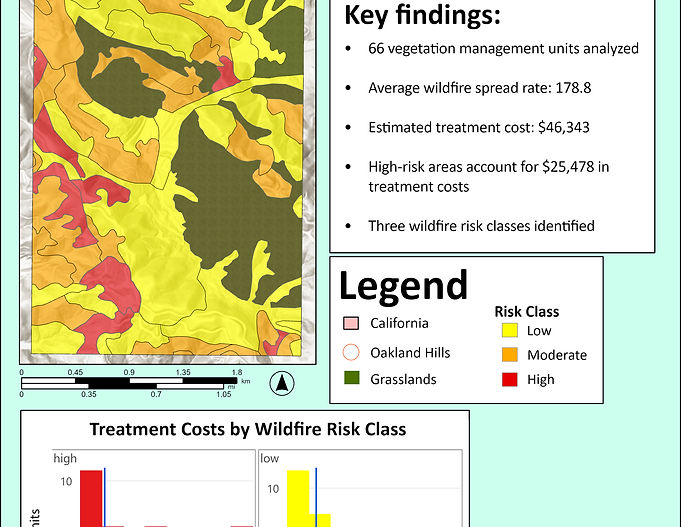
Wildfire Risk Classification & Fuel Treatment Cost Analysis
Vegetation Risk Classification & Treatment Cost Analysis
Evaluated vegetation characteristics and wildfire behavior indicators to classify wildfire risk across vegetation management units in the Oakland Hills, California. Applied vector analysis, attribute queries, geoprocessing, and field calculations in ArcGIS Pro to estimate vegetation treatment costs by risk class and produce decision-support maps and charts supporting fuel reduction planning, wildfire mitigation, and natural resource management.
Project Context: Originally developed through the University of Vermont's Advanced GIS course (GIS & Data Communication Certificate) and later refined for my professional portfolio.
Software: ArcGIS Pro
Spatial & Data Analysis: Spatial Analysis, Vector Analysis, Attribute Queries (SQL), Geoprocessing, Field Calculations, Data Classification
Environmental Applications: Wildfire Risk Assessment, Fuel Treatment Planning, Natural Resource Management
Decision Support: Cost Analysis, Treatment Prioritization
Cartography & Visualization: Cartography, Data Visualization